


The municipal road leading to Franscia and Campo Moro will remain closed for the summer season.
Given this extraordinary situation, which inevitably alters the logistical accessibility of a major portion of our territory, the Valmalenco UltraDistance Trail organization — in coordination with the Municipality of Lanzada and in full agreement with the unappealable judgment of the race safety team (comprising Race Direction, Course Manager, Alpine Rescue, SAGF Alpine Rescue of the Guardia di Finanza, Italian Red Cross, and local authorities) — has made the mandatory decision to modify the 90km and 35km courses.
The inability to reach Campo Moro using traditional vehicles would deprive the race of a crucial logistical base for event management: the road to Campo Moro is strategic and necessary for ambulance access, rescue positioning, volunteer transport, managing retired runners, and relay handovers. Therefore, it would be impossible to guarantee high safety standards for 2026. For this reason, the entire section from Val di Scerscen down to the descent towards Caspoggio is necessarily excluded from the route.
The new 90k and 35k courses preserve the technical and spectacular spirit of the VUT, traversing brand-new trails, mountain huts, and landscapes never touched by the race before.
New routes have been identified with difficulty levels, distances, and elevation gains comparable to the original course. ITRA points and UTMB qualification levels remain unchanged.
The course will pass by 4 mountain huts not included in the original route: Tartaglione Crispo, Del Grande Camerini, Motta, Alpe Ponte.


90K COURSE DETAILS
Key Data
| Distance | 83 km |
|---|---|
| Positive Elevation Gain | 6,100 m D+ |
| ITRA Points | 4 |
| UTMB Qualification | 100K |
What's New on the Route
- New climb towards Arcoglio, Sasso Bianco, and Lake Zana.
- Entry into Val Sissone with Rifugio Tartaglione Crispo and Rifugio Del Grande Camerini.
- Final stretch featuring Lake Palù, Rifugio Motta, and a technical descent towards Lanzada.
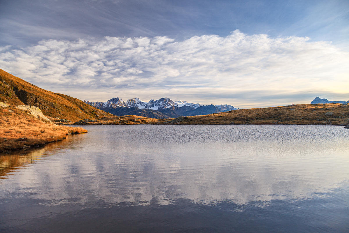
Lake Arcoglio - photo by R. Ganassa
VUT 90K Map
VUT 90K Time Barriers
| CHECKPOINT | DISTANCE | TIME | RACE TIME |
|---|---|---|---|
| Lago di Chiesa | 28 km | Saturday 06:00 | 8h |
| Chiareggio | 40 km | Saturday 11:00 | 13h |
| Chiareggio | 54 km | Saturday 14:00 | 16h |
| Paluetto | 66 km | Saturday 17:00 | 19h |
VUT 90K Aid Stations
|
AID STATION |
DISTANCE | ALTITUDE | TIME CUT | |
|---|---|---|---|---|
| Alpe Piasci | 10 km | 1600 m |  |
|
| Rifugio Bosio | 24 km | 2020 m |   |
|
| Laghi di Chiesa | 28 km | 1620 m | |
8h |
| Rifugio Ventina / Gerli-Porro | 43 km | 1950 m | |
|
| Chiareggio | 40 km | 1600 m |  |
13h |
| Rifugio Tartaglione Crispo | 44 km | 1770 m | |
|
| Rifugio Del Grande Camerini | 47 km | 2500 m | |
|
| Chiareggio | 54 km | 1600 m | |
16h |
| Rifugio Longoni | 59 km | 2400 m | |
|
| Paluetto | 65 km | 1620 m | Time barrier only | 19h |
| Rifugio Lago Palù | 66 km | 1950 m | |
|
| Rifugio Motta | 70 km | 2170 m | |
|
| Alpe Ponte | 76 km | 1550 m | |
VUT 90K Relay Handovers
- Laghi di Chiesa — road accessible by car.
- Chiareggio — second passage.
| LEG | DISTANCE | ELEVATION GAIN |
|---|---|---|
| 1st Runner | 28 km | 2,019 m D+ |
| 2nd Runner | 26 km | 2,287 m D+ |
| 3rd Runner | 29 km | 1,721 m D+ |
Locations Passed VUT 90K
Chiesa in Valmalenco, Vassalini, Torre Santa Maria, Ciappanico, Alpe Son, Alpe Piasci, Alpe Canale, Arcoglio, Sasso Bianco, Lago di Zana, Zana, Rifugio Bosio, Alpe Airale, Alpe Lago, Alpe Pirlo, Alpe Pradaccio, Laghetti Sassersa, Passo Ventina, Rifugio Ventina, Rifugio Gerli Porro, Chiareggio, Vazzeda inferiore, Rifugio Tartaglione Crispo, Alpe Sissone, Rifugio Del Grande Camerini, Vazzeda Superiore, Alpe Monterosso, Alpe dell’Oro, Chiareggio, Alpe Fora, Rifugio Longoni, Alpe Entova, Alpe Paluetto, Rifugio Palù, Alpe Palù, Rifugio Motta, Alpe Campolungo, Cima Sassa, Alpe Ponte, Tornadri di Lanzada, Curnasch, Curada, Caspoggio.
35K COURSE DETAILS
Key Data
| Distance | 36 km |
|---|---|
| Positive Elevation Gain | 2,300 m D+ |
| ITRA Points | 2 |
| UTMB Qualification | 50K |
What's New on the Route
- Passage through Palulungo, Senevedo Superiore, and Lake d’Entova.
- Return to the shared route with the 90k, passing by Rifugio Palù and Rifugio Motta.
- Final descent towards Alpe Ponte, Lanzada, and Caspoggio.
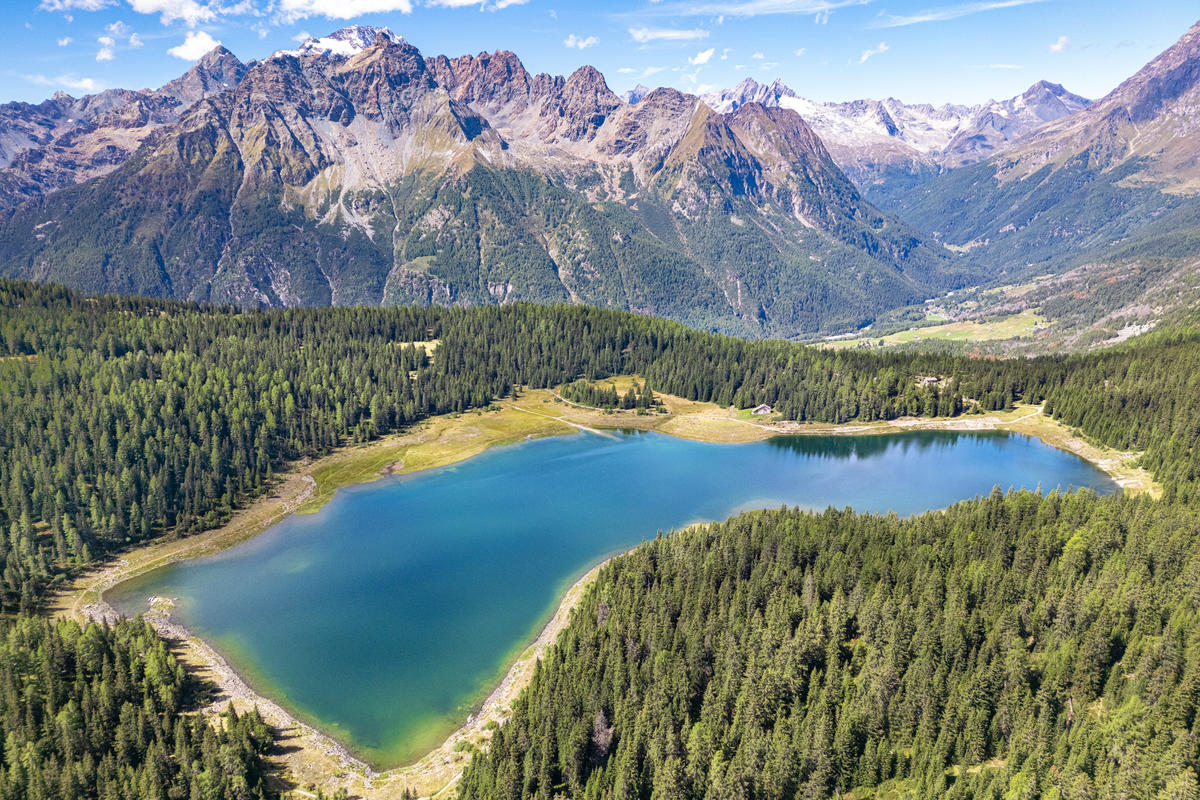
Lake Palù - photo by R. Ganassa
VUT 35K Map
VUT 35K Time Barriers
| CHECKPOINT | DISTANCE | TIME | RACE TIME | ELEVATION GAIN |
|---|---|---|---|---|
| Paluetto | 18 km | Saturday 15:00 | 6h | 1,600 m D+ |
VUT 35K Aid Stations
|
AID STATION |
DISTANCE | ALTITUDE | TIME CUT | |
|---|---|---|---|---|
| Albareda | 6 km | 1400 m | |
|
| Prati Pedrana | 9 km | 1520 m | |
|
| Paluetto | 17 km | 1620 m | Time barrier only | 6h |
| Rifugio Lago Palù | 19 km | 1950 m | |
|
| Rifugio Motta | 23 km | 2170 m | |
|
| Alpe Ponte | 28 km | 1550 m | |
Locations Passed VUT 35K
Lanzada, piazza del Magnan, Vassalini, Albareda, Barchi, Palulungo, Lago d’Entova, Rifugio Palù, Alpe Palù, Rifugio Motta, Alpe Campolungo, Cima Sassa, Alpe Ponte, Tornadri di Lanzada, Curnasch, Curada, Caspoggio.